| Submission Procedure |
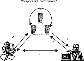
Knowledge Management and Environmental InformaticsKlaus Tochtermann Hermann Maurer Abstract: The objective of this paper is to identify synergy fields and relationships between knowledge management and environmental informatics. From the perspective of knowledge management many sophisticated techniques, concepts, and methodologies developed in the domain of environmental informatics can build the starting point for finding answers to open questions in knowledge management. For example, meta-knowledge management can capitalise on existing results gained in the area of metadata management, which plays a key role in environmental informatics. Up to now, many tools for knowledge processing have been applied in the domain of environmental informatics to help solve environmental problems. New knowledge management tools can improve this situation which in turn contributes directly or indirectly to a significant improvement of the protection of our environment. In order to achieve its objective, the paper introduces knowledge management with a strong focus on information technology. This introduction is followed by a literature survey on knowledge processing in environmental applications. Thereafter, several environmental information systems are analysed in the light of knowledge management. A special emphasis is placed on how geographical information systems can be used for knowledge management. Finally, the paper closes with suggestions of further areas of research in the synergy field of knowledge management and environmental informatics. Keywords: Knowledge Management, Information Systems, Data Bases, Environmetal Data, Visualization Categories: H.1, H.2, H.3, H.4, J.3 1 IntroductionAccording to a recent Ovum report, the need for knowledge management software and infrastructure will grow from $ 285 in 1998 to $ 1.6 billion in 2002 concerning the expenses for such systems [Woods et al. 1998]. According to a study on knowledge management conducted by Murray and Myers [Murray et al. 1999] 85% of companies believe a value can be attached to business knowledge and business must do three things effectively in the next three years - find and capture the knowledge they have got, and share it and exploit it to some commercial benefit. 85% of the core 100 companies agreed - "if we knew what we know, then we would be far more productive". The result of these two studies are representative for further similar Page 517 studies: knowledge management has become an organisational imperative for all types of corporate, governmental and non profit organisations. The key objective of knowledge management is to apply the knowledge which resides either explicitly or implicitly within an organisation to achieve most efficiently and cost-effectively the organisation's goals. Even though knowledge management comprises three dimensions, i.e. socio-cultural, business economic and information-technological, we focus primarily on aspects which are related to information technology (IT). For the other two dimensions the reader is referred to [Petkoff 1998]. The use of information technology for knowledge management is discussed controversially: History in science shows that new technologies/methodologies often raise too high expectations which cannot be fulfilled in the long run. There are thinkers, who argue that the new computer age is bringing a second flood, whereby we risk being drowned in the massive amounts of knowledge and information. Their pessimistic view is that there is simply too much knowledge to cope with. This view is supported by the assessment that the collective knowledge of the emerging Information Society doubles every five to ten years. In addition, they fear that IT-based knowledge management drives organisations towards massive investments in IT, possibly at the expense of investments in human capital [Borghoff et al. 1997]. More optimistic thinkers argue that modern information technologies provide means to bring together people even over long distances (e. g., by email, videoconferences etc.), they help connect the "problem owner" to the "solution provider" and thus foster the knowledge sharing among people. Viewed from this perspective knowledge management emerges primarily as people and process issue which can be supported but not replaced by IT. Of course, the optimistic thinkers are aware of the fact that a change of culture within organisations is required: the traditional "need-to-know" cultures are becoming obsolete and will be replaced by "want-to-know" cultures. Such cultures require fewer hierarchies, more freedom and empowerment of the employees which in turn provide frameworks which support the best possible development for the employees. Environmental informatics - the second research field addressed in this paper - is concerned with the design and development of methodologies and tools to manage data about the soil, the water, the air, and the species in the world around us. According to a directive of the European Union, almost all environmental information that is stored at public agencies has to be made available to every citizen on demand. As a result of these political and economic developments, there is a major demand for environmental information and appropriate tools to manage it. Environmental information is typically made up of a variety of different data types. In addition to the disparity of type, environmental data objects are often quite large in size. Therefore, support based on metadata for distributing, searching for, retrieving and utilising this data is imperative in order for environmental information to be used to its maximum potential benefit and effectiveness. Against this background the purpose of this paper is to identify synergy fields and relationships between knowledge management and environmental informatics: From the perspective of environmental informatics, many application domains (e.g., knowledge transfer, knowledge retrieval etc.) exist in which knowledge management can contribute directly or indirectly to a significant improvement of the Page 518 protection of our environment. For example, integrated environmental information systems call for process-oriented rather than functional structures in any type of organisation. To this end, process-oriented knowledge management as a sub-discipline of knowledge management opens up many windows of opportunities. From the perspective of knowledge management many sophisticated techniques, concepts, and methodologies developed in the field of environmental informatics are useful for all other fields of knowledge management. For example, outside environmental informatics there are only very few research fields in computer science which have built up such a profound and wide experience in metadata management. And as pointed out above, it is evident that metadata management will play a crucial role in knowledge management. Additionally, for knowledge access and retrieval, new interactive metaphors are required simply because the treasure of knowledge which exists in knowledge bases should not be made accessible only through standard and inflexible text-based user interfaces. The rapid development in the area of Internet-based geographical information systems makes possible new interaction metaphors to access complex knowledge bases; metaphors one could not have thought of five years ago. To identify existing and to elaborate new synergy fields between knowledge management and environmental informatics, the paper is structured as follows: Section 2 introduces knowledge management with a special focus on information technology. Section 3 gives a literature survey of research dealing with knowledge processing and environmental applications. According to our notion of knowledge management introduced in Section 2, Section 4 analyses several environmental information systems in the light of knowledge management. Section 5 illustrates how most advanced technologies in multimedia cartography and geographical information systems can be applied for knowledge management. Finally, Section 6 provides further areas of research which are worth future investigations. The paper ends with a conclusion in Section 7. 2 Information Technology for Knowledge ManagementInformation technology is used pervasively in organisations and thus qualifies as a natural medium for the flow of knowledge. The application of information technology for knowledge management helps to create, archive and transfer knowledge. It can ensure that knowledge is meaningful (content), relevant (context) and accurate (timely and trustworthy). Also, since knowledge is more than passive information in isolation, IT can be applied as an enabling technology for interaction and collaboration for a knowledge community. However, one should be aware of the limits of information technology: the introduction of an IT-based knowledge system will not achieve much, if a cultural change towards knowledge values has not taken place. The highest acceptance of a knowledge management system will be achieved if the cultural change has raised needs and expectations first which can then be met best with support of IT-driven knowledge management. The implementation of IT-related knowledge management in organisations should be built on the following cornerstones: corporate environment, knowledge retrieval and knowledge transfer. Page 519 Corporate environment, i.e. an organisation's "memory", is about maximising the return on intellectual assets. It seeks to find, select and organise the intellectual capital of an organisation and then present that knowledge in a way that helps employees to comprehend and act on that information for the sake of the customer, a product or a market. In the old, static pattern schooling took place before work. A "good education" was a one-time event. The emerging Information Society has changed this pattern dramatically. Today organisations are required to continuously extend the knowledge and skills of their employees to meet requirements in new global markets, economies and societies. It seems evident that knowledge transfer, i.e. the integration of lifelong education and training in our private and working life, will play a central role in this context. Knowledge at your finger-tips is certainly one of the most attractive visions knowledge management can offer to its users. Knowledge retrieval helps make this vision become reality. It focuses on powerful and flexible packaging of technology, based on open paradigms for multimedia navigation, annotation and retrieval and a fundamentally open-ended environment for the configuration of the tools to the user's needs. 2.1. Key Aspects of Knowledge ManagementThe following figure shows that in a knowledge management system humans and computers are involved. As pointed out before, knowledge management has the aim to nurture, archive, share and increase human knowledge.
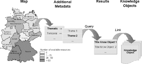
Figure 1: Key aspects of knowledge management Page 520 The arrow 3 Knowledge Processing in Environmental ApplicationsMany papers have been published about the application of methods and tools for knowledge processing in the domain of environmental informatics. Most of the research places the emphasis on the application of expert systems to help solve environmental problems. This section cannot be exhaustive but tries to give an overview of the most relevant achievements in this field. The FOREX expert system [Dorn et al. 1998] has been developed for the management of forestries and especially for the rehabilitation of forest ecosystems dominated by Norway spruce. The system implements a methodology for providing foresters with concrete recommendations of how to restore and manage forest ecosystems. Venema illustrates the use of neural networks for waste-water purification, more precisely the prediction of ammonia concentration in waste-water [Venema et al. 1998]. A combination of neural and fuzzy logic is applied by Pokrovsky [Pokrovsky 1998]. This research deals with simulations of meteorological processes at the earth surface. It is closely linked to global climate change investigations and to complex processes occurring in ecosystems. Model-based diagnosis techniques are used by [Heller et al. 1998] to asses the situation of our ecosystem from a limited number of observations. Such assessments are crucial moments to decide about possible cures or symptoms treatments to put an ecosystem in a condition that is in accordance with some specified goals. In [Wiering et al. 1998] an intelligent system based on reinforcement learning is described. The system supports decision makers to control forest fires. PRO-PLANT is a knowledge-based plant protection advisory system [Visser et al. 1999a]. PRO-PLANT supports fungicide and growth-regulator consultations for cereal and sugar beet productions; it also provides consultations on herbicide usage in corn, and insecticide usage in winter rape. Finally it is worth mentioning the XUMA-GEFA expert system [Ferse et al. 1997]. XUMA-GEFA helps assess the environmental dangerousness of residual waste Page 521 in industrial areas. Based on the assessment recommendations for concrete actions can be given. Even though many approaches exist to integrate knowledge processing with environmental applications, one can observe that most of the systems are at a prototype level. Only very few systems are used in environmental organisations or are even available as a product. 4 Integrating Knowledge Management in Environmental InformaticsThis section shows by representative examples in which way each of the three knowledge management components (i.e., corporate environment, knowledge retrieval and knowledge transfer) can be integrated in environmental information systems. 4.1 Corporate Environments and Environmental Information SystemsThe main objective of the DIWA system [Henning et al. 1999] is to build up, maintain and use a web-archive for environmental documents (e.g., minutes, environmental regulations, environmental reports etc.) The web-archive can be structured along thematic or organisational aspects of the organisation which uses the DIWA system. It is independent from any file or server system and can therefore be tailored in a way which reflects best the structure of the corporate environment of an organisation. The publishing component of the system allows users to make available their documents to other users. This includes to define relevant metadata for the documents which improves the retrieval of the documents by other users. With the current version of the DIWA system it is only possible to explicitly input human knowledge in the knowledge base. Mechanisms to create new knowledge by systemic actions or as by-product of actions users carry out anyway are not supported. Up to date corporate environments exist for two different departments in the Ministry for traffic and environment in the Southern State of Baden-Württemberg of Germany. One of the corporate environments comprises the whole knowledge about unpublished but binding regulations of the State of Baden-Württemberg while the other represents the knowledge about the modernisation of the remote monitoring system for nuclear energy plants in Baden-Württemberg. H.I.R.N. (Hypertext Information Retrieval Network) is an internet-based environmental information system for environmental regulations and laws [Riekert et al. 1997], [Strauß et al. 2000]. The content is provided by publishing houses. The users of the H.I.R.N. system, however, can extend this content with their personal interpretations and comments. Such personal comments can be made available to all other system users or to well-defined groups of users only. It is possible to comment on comments of other users so the system can be used as an online discussion forum within an organisation. The sum of all individual comments and online discussions reflects an organisation's corporate knowledge about the environmental regulations. In addition to the possibility of explicitly providing knowledge for the corporate Page 522 environment implicit knowledge can also be captured with H.I.R.N. In H.I.R.N. the concept of profiles is defined as a structured collection of documents which are pertinent to perform specific tasks. Users have the freedom of choice to build up as many profiles as they need for their task. The profiles with the documents assigned to them reflect implicit knowledge in that the system or other users can deduce from a profile which documents belong together for specific tasks. Up to date the H.I.R.N. system is lacking a component which automatically creates explicit computerised knowledge based on this implicit knowledge. Still, authorised users can manually transfer this implicit knowledge to explicit knowledge to provide it to the other users. Yet another system with knowledge management components is the PADDLE system (Personal Adaptable Digital Library Environment). PADDLE is a digital library environment for knowledge workers which contains thousands of environmental documents (e.g. texts, graphics, tables about the State of the Environment in Germany) [Tochtermann et al. 1999], [Tochtermann et al. 2000a]. The approach for building up corporate knowledge with PADDLE covers three aspects. Firstly, an organisation has to identify the type of knowledge they want to make available in a corporate environment. The type of knowledge may include reports, product descriptions, minutes, project reports, work practices etc. Secondly, an organisation has to categorise the user groups working with the knowledge base or well-defined parts of it. In this context the PADDLE philosophy is that different knowledge workers need different views of the corporate environment and the knowledge stored therein. Thirdly, for each type of knowledge templates are provided which support the knowledge workers in preparing the knowledge they want to add to the corporate environment. A particular focus is placed on a quality assurance component. Before knowledge is made available widely in PADDLE it has to undergo a quality assurance process. In the PADDLE system, the quality assurance process is part of a workflow which serves the purpose to disseminate, review, edit and release information resources in a pre-defined chain of users. Quality assurance components are becoming increasingly important as the level of quality of the knowledge in a corporate environment directly influences the level of acceptance to use this knowledge base. In other words: the higher level of quality the higher the user acceptance. 4.2 Knowledge Retrieval in Environmental InformaticsFor knowledge retrieval in environmental informatics, often ontologies are applied. An ontology is an explicit specification of a conceptualisation [Gruber 1992]; that is an ontology is a shared understanding of some domain interest, specified in the form of definitions of representational vocabulary and axioms with constraint interpretations over this vocabulary. Ontologies are crucial for knowledge retrieval as they can give a unique semantic to complex objects. Our literature study revealed that the application of ontologies in the domain of environmental informatics requires many different ontologies for the different characteristics which exist for environmental data (e.g. temporal, geographical, thematic an organisational relationships). Against this background one should trade Page 523 off carefully between the time needed to set up and maintain environmental ontologies and the gain of time as well as the quality of search results for the users. Here are some examples for environmental ontologies: The environmental information system of the German city of Bremen allows its users to enrich the existing information with personal annotations [Schröder et al. 1998]. The annotations are created with an annotation language which is based on ontologies. This annotation language is specifically designed to embed and retrieve efficiently knowledge within HTML pages. The underlying methodology is referred to as the Ontobroker approach [Decker et al. 1999]. The ontobroker approach provides brokering services to improve access to heterogeneous, distributed and semi-structured information sources. It relies on the use of ontologies to make explicit the semantics of HTML pages. As the ontobroker approach does not depend on a specific application domain it can be applied as knowledge management component in almost every type of environmental system. For example, ontologies for regulations are being developed by [Schröder et al. 1998]; [Visser et al 1999b] are working on an ontology for information integration and retrieval of geographical information. Ontology-based knowledge retrieval for heterogeneous and distributed environmental information is applied by [Stuckenschmidt et al. 1999]. In this approach the focus is placed on deriving implicit knowledge from semantic descriptions of concepts. An interesting approach referred to as Ecolingua links ontologies to metadata [Uschold et al. 1996]. Ecolingua is an ecological metadata ontology prototype. It provides vocabulary needed for formal descriptions of ecological data properties. The ecological metadata ontology is used to generate prototypical partial ecological models through logic-based knowledge representation and inference. Metadata management plays a crucial role in environmental informatics [Greve et al. 1999]. Prominent examples for an environmental metadata system are the environmental data catalogue [Nikolai et al. 1999] and the catalogue of data sources [Pick et al. 2000] of the European Environment Agency. It is worth mentioning that either system does also provide data about contact persons who can help users in specific domains. This is a promising starting point to extend such systems to meta-knowledge systems (meta-knowledge is knowledge about knowledge). Rather than providing users with the actual knowledge, meta-knowledge systems contain information about people who have knowledge or expertise in a certain domain. Meta-knowledge systems are complementary to knowledge management systems as they help connect people to one another and, thus, can be regarded as an enabling technology. In analogy to directories meta-knowledge spaces are often referred to as "yellow pages". 4.3 Knowledge Transfer in Environmental InformaticsKnowledge transfer deals with the mapping of computerised knowledge onto human knowledge. Knowledge transfer becomes increasingly important in the field of environmental management information systems. The reason is that environmental assessment schemes such as the voluntary European Eco Management and Audit Scheme (EMAS) or ISO 14001 are undergoing rapid changes, which have to be followed continuously by auditors, environmental consultants and the environmental Page 524 managers of the certified organisations. Even though knowledge-based training and education tools can significantly help keep pace with these fast developments only few approaches in this direction exist. The basic connection between knowledge management and knowledge transfer is pointed out in [Maurer 1999]. [Dade et al. 1998] introduce a concept to integrate environmental management information systems with distance education tools. Their research revealed that all teaching tools can use model data only. This is due to the fact that the real environmental data varies from one organisation to the other. The use of model data bears the risk that users do not recognise the benefit of using the system as it does not reflect their organisation. Often this results in a decreased motivation of using such a system. To improve the situation, deeper levels need to be illuminated to really understand what knowledge modules are. Normally, knowledge modules are regarded as a pair consisting of knowledge and meta-knowledge only. In our opinion additionally convention specifications are needed. Convention specifications define which symbols or data in a knowledge module have to be exchanged by others to adapt the knowledge to a new context or even to create new knowledge. Another possibility to improve the situation is to develop educational knowledge modules which measure if the degree of knowledge users have in a certain field is sufficient to cope with situations which typically occur in this field. To address this issue two aspects have to be taken into account. Firstly, the system needs to "know" how much and which knowledge is required to cope with such situations. Secondly, based on this knowledge the system has to determine whether the knowledge of users is sufficient compared to the knowledge which they are supposed to have. For example, for environmental assessment schemes such a system could offer a meta-course on material flow and life cycle analysis in a company. Instead of teaching a material flow and life cycle analysis course, the course helps environmental managers and environmental consultants assess if their knowledge is sufficient to analyse material flows in a company. If the knowledge is insufficient the system might confront them with the consequences that arise due to too little knowledge. Examples for such consequences, are a dramatic increase of material costs or the failure of the EMAS or ISO certification. In the field of environmental informatics first contributions have been published which deal with the design and the layout of environmental and geo-information. It emerges that interactive animations help users to better understand the often very complex relationships of environmental processes. The animations lead to an increase in user activities which in turn facilitates explorative learning [Buziek 1998]. In addition to explorative learning strategies also collaborative problem-based learning strategies are applied in environmental domains [Zumbach et al. 2000]. The idea of problem-based learning is to solve specific problems. By doing this the users learn about the problem domain so that the way how the problem is solved is more important than the actual solution. Zumbach found out that the possibility to access background libraries during the course of solving problems further enhances the knowledge transfer. The access to background systems - which often exist in environmental information systems [Greve et al. 1999] - ensures the avoidance of the "tunnel syndrome". The tunnel syndrome is the users' impression that there is only one direction in which they can go to accomplish a given task. Page 525 5 Geographic Information Systems and Knowledge ManagementThe advancements of Internet technologies, of interactive multimedia cartography and of geographical information systems (GIS) have generated an increasing interest in interactive multimedia mapping tools [Cartwright et al. 1999], [Gartner 2000]. Such tools offer opportunities which one could not have even thought of five years ago. The purpose of this Section is to give an overview of how Internet-based GIS can be best exploited for knowledge management. The original idea for GIS was to computerise the metaphor of a thematic map. This leads to the definition that GIS are computer-based tools to capture, manipulate, process, and display spatial or georeferenced data [Günther 1998]. Since environmental information is always related to a geographic region or a location, e.g. the location of a lake, GIS is an essential tool for the management and visualisation of environmental information. Before we delve into further details we analyse how georeferenced data is already applied in the field of digital catalogues. 5.1 Georeferenced Data and Digital CataloguesResearch in the area of digital catalogues revealed that well accepted standards exist (e.g. Dublin Core, [Weibel 1999]) for defining a minimal set of meta-information which can be used to systematically catalog an information resource [Tochtermann et al. 1997]. Among the set of meta-information there are elements for describing the title, the author, subject and keywords etc. of an information resource. There is another element which is neglected in many digital catalog systems: "coverage". The element coverage can be used to describe the geographical characteristics of the intellectual content of the resource. Geographical coverage refers to a physical region using geographical names or coordinates (e.g., longitude and latitude). Often geographical coverage is associated only with typical geo-data such as environmental data, remote sensing data and images from satellites and aircraft, databases of measurements (e.g. temperature, windspeed, snow depth) from specific geographic locations etc. However, in reality almost every type of information has a geographical reference. For instance, regulations can be geo-indexed with the country or state they are valid in, scientific literature can be geo-indexed with the place of publication, servers can be geo-indexed with their location in a network etc. And indeed there already exist first examples of "network topology maps" created by Internet service providers and Internet backbone operators [Dodge 2000]. The maps are often created for promotional purposes to demonstrate the large bandwidth and good connections available. Additionally, they can also be used for topological searches for servers and internet operators. The curious reader is invited to try out the Mapnet tool which visualizes simultaneously the topology of the infrastructure of multiple U.S. backbone providers [Claffy et al. 2000]. The wide applicability of georeferenced data resulted in the idea to enhance search and retrieval in digital catalogs by using not only semantic and temporal relationships but also geographical relationships [Tochtermann et al. 1997], [ADL 2000]. Typically, geographical relationships can restrict the search to resources which Page 526 are related to a geographical region. Two ways exist to define the geographical relationship: 1) Similar to choosing keywords for semantic relationships, users can choose a geographical name (e.g. "Graz") to define the geographical relationship; 2) a technique referred to as geographical access can be applied [Kraak et al. 1997]. Geographical access means that users specify coordinates by clicking on a point, on a geo-object, by defining a rectangular or polygonal geometry etc. While existing user interfaces of digital catalogs have in common that different components exist to define the different relationships for a query a new idea is to apply geographical information systems and multimedia cartography as integrated information portals in knowledge management systems. In general, a common understanding for an information portal is that it provides "knowledge workers with a secure, single point of exchange of relevant information, both structured and unstructured, both inside and outside of the organization through a standard Web browser interface" [Hyperwave 1999]. The Sections 5.2 and 5.3 describe the potential of geographical relationships for the mediation of knowledge resources. They also illustrate that interactive, graphical information portals to corporate environments open up new opportunities for intuitive knowledge retrieval. 5.2 Intelligent Maps for Knowledge RetrievalAs pointed out above geographical search components cannot only support geographical relationships but can also be combined with other relationships such as thematic and temporal relationships. In principle there exist two ways which allow this combination. Firstly, ideas from conceptual navigation can be applied [Veltman 1997]. Conceptual navigation supports users systematically in narrowing their scope of interest by forming strategic sequences of why? (purpose), how? (means), when? (temporal boundaries), where? (geographical boundaries), what? (subject) and who? (person). This means that users select geo-objects on the map to define the geographical relationship; the system then returns all knowledge resources which match this relationship. In a second step users define textually other relationships to filter the resources of interest. The drawback of this approach is that the query interface would be a mixture of an interactive, graphical interface and a textual interface. Secondly, ideas from the concept of smart maps can be extended. The concept of smart maps is defined as a concept of visualization of one or more relationships between information resources and places on a map [Rose et al. 1999]. For example, the description of a forest can be correlated to a region on a map representing the physical location of the forest. This reference is animated (e.g. in form of a popup menu) by a sensitive area on the map which appears when the users moves a pointing devices over the map and enters the region. A popup menu can show the users the titles of all information resources linked to the respective region. Selecting a title will retrieve the information resource. The implementation of smart maps requires to link all relevant information related to a named region on the map of interest. A drawback of the approach described in [Rose et al. 1999] is that no geographical information Page 527 system is used to relate an information resource automatically (e.g., based on its geographical relationship) to a region on a map. This means whenever a new resource is added to the corporate environment an explicit assignment of the resource to a region on a map is required. Of course, one can easily imagine that this is not feasible for corporate environments with a high update frequency. Our idea is to extend the concept of smart maps in the following way (c.f. figure 2: In a first step the user interactively selects a geo-object on a map. In a next step a menu pops up providing a structured subject tree. The subject tree contains all thematic relationships of knowledge resources which are indexed with the respective geo-reference. Users select one or more entries in the subject tree to define the thematic relationship for their query.
Figure 2: Intelligent maps The same approach can be applied to other relationships. In this alternative the maps would have a certain degree of intelligence in that each geo-object "knows" which thematic and other relationships those knowledge resources have which are indexed with this geo-object. This, however, can be computed automatically after every update of the corporate environment and thus would not affect the performance of the query component. Page 528 5.3 Making Visible the Otherwise InvisibleMost map-based interfaces do not show if information is available at all for geographical regions on the map. Queries often lead to empty search results since it is not visible to the user if knowledge resources exist for the selected geographical region. Therefore, a great challenge is to overcome this problem, i.e. to make visible the otherwise invisible. Our approach to address this issue is as follows: Different maps with different scales are provided for the selection of a geographical relationship. This ensures that users can start their searches with a large scaled map (i.e. a map with a low the level of detail) which will retrieve more results than small scaled maps. As users become familiar with the system they can change the scale of maps at their will to restrict their queries to more precise geographical relationships. Additionally, the concept of intelligent maps as introduced in Section 5.2 can be enriched with a memory which "knows" the geo-objects to which knowledge resources exist. Such a memory can be maintained automatically. Whenever users select a geo-object which is stored in the memory, the system can automatically - without querying the corporate environment - return the information if or if not knowledge resources with this geographical reference are available.
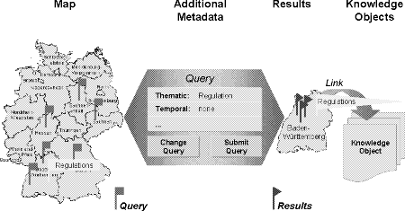
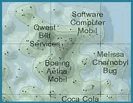
Figure 3: Using footprints to make visible the otherwise invisible Footprints on maps are yet another a well-known concept in literature [Larson 1995]. The idea is to provide footprints as hypermedia links on a map. Footprints enable users to mark the locations of important documents (c.f. figure 3). Clicking on a footprint with a pointing device (e.g. mouse) brings up knowledge resources Page 529 referenced by the link. The problem with this approach is that if all footprints are shown simultaneously the map may disappear entirely. Therefore, we capitalise on the idea of footprints in another sense. Many information portals allow users to store their queries for later purposes [Hyperwave 1999]. Similar to this, one can visualize stored queries as footprints on maps. Whenever users select a footprint users can either submit the query or adapt it to their current needs (c.f. figure 3). To avoid the problem that maps get again overloaded by too many footprints from a variety of users we allow users to design their personal maps with their personal footprint. This is an important contribution to a new emerging research area: personalization and customization in internet-based information systems [Tochtermann et al. 1999]. For more information about the integration of customizable geographical information portals in knowledge management environments, the interested reader is advised to consult [Schwartz et al. 2000]. The architectural design for geographical portals is described in [Tochtermann et al. 2000b]. A further starting point for applying GIS and multimedia cartography for knowledge and information management is the area of information space maps [Dodge 2000]. Information space maps are two or three dimensional maps which can be seen as analogous to conventional landuse maps. Sophisticated indexing and classification methods are employed to produce these maps. The aim of these maps is to provide a sense of the "lie of the land" of an corporate environment to support searching and retrieval. The concept of "NewsMap" is another promising approach for exploiting techniques of environmental informatics for knowledge management in general and knowledge retrieval in particular (c.f. figure 4) [NewsMap 2000]. NewsMaps look like topographical maps of mountains and valleys. The concept of the layout is simple: documents with similar content are placed closer together, and peaks appear where there is a concentration of closely related documents. The valleys between peaks can be interesting because they contain fewer documents and more unique content. Topic labels (e.g., software, computer, mobil) reflect the major two or three topics represented in a given area of the map, providing a quick indication of what the documents are about. Future activities in this field will certainly exploit the benefits of the Vector Markup Language (VML) [VML 2000]. VML is an XML-based exchange, editing, and delivery format for high-quality vector graphics on the Web. Rather than referencing graphics as external files, VML graphics are delivered inline with the HTML or XML page, allowing them to interact and scale with user interaction. If applied for maps some the above described geo-functionality could be used in knowledge management systems without being forced to use a GIS to interact with the maps. Impressive applications of VML for interactive maps on the Internet can be found at http://www.vmlsource.com/. Page 530
Figure 4: NewsMaps 6 Further Synergy Fields for Knowledge Management and Environmental InformaticsThis Section introduces further starting points for the integration of knowledge management and environmental informatics. A particular emphasis is placed on those aspects introduced in Section 2 which have not yet been addressed in detail. To our knowledge, currently, no system exists in the field of environmental informatics which provides functionality to derive new knowledge from already existing knowledge. Metadata which play a crucial role in environmental informatics can be used as a starting point for research in this direction. For example, the thematic relationship of environmental data is normally defined with support of an environmental thesaurus [Batschi 1994]. The explicit structures within a thesaurus (e.g. synonyms, broader, narrower, and related terms) can be used to identify relationships between different documents. These relationships can be made explicit by automatically defining hypermedia links between the corresponding documents. Similarly, temporal relationships can be used to define explicit predecessor-successor relationships between documents. While this paper mainly concentrates on product-oriented knowledge management, i.e. the creation, maintenance, reuse, and use of knowledge in a form which can be handled by information technologies, process-oriented knowledge management has a slightly different focus. According to [Studer et al. 1999] process-oriented knowledge management aims at enabling people to apply their knowledge and skills in an optimal way to perform jointly a process. Many organisations are currently re-organising their internal structure. While often functional structures exist, one can observe a shift towards process-oriented structures in organisations. Process-oriented Page 531 structures divide all activities and all tasks of an organisation into processes which are arranged according a logic order, a temporal order etc. Process-oriented structures in organisations are a pre-condition for the introduction of modern integrated environmental management systems, that is systems which do not only cover environmental aspects but also quality assurance and operational safety within an organisation [Kürzl 1998], [Seder et al. 1998]. The integration of all these aspects necessitates that people with different knowledge, expertise and skills become involved in the different processes within an organisation. These processes can only be handled and performed effectively if all experts involved share their knowledge with other people who are affected by this process. It is evident that process-oriented knowledge management components can enhance the added value of integrated environmental management systems. Two reasons are supporting this assessment: Firstly, integrated environmental management systems are a very natural application domain for process-oriented knowledge management. Secondly, process-oriented knowledge management components empower people to collaborate with one another, to share their expertise and thus help integrate the different aspects related to environmental issues, quality assurance and operational safety. According to Buziek [Buziek 1998] there is an increasing need to design and present environmental information more attractive than it used to be in the past. Today's multimedia authoring tools support the creation of multimedia documents at a very concrete level only [Lennon et al. 1994]. Why more abstraction is necessary goes back to the "missing organ theory" first explained in [Maurer et al.1994]. Therefore, only very limited possibilities exist to reuse a document in many different contexts. In addition, the mental model of the author normally does not match well with the mental model of the viewer. To explain this, we take an analogy from books and movies. Often people are so enthusiastic about a book they have read that they also want to watch a movie about the story of the book. Sometimes, however, people do not like the movie and are disappointed about it. The reason for this phenomenon is that the book and the movie are at different levels of abstraction. While the movie is very concrete (e.g., the main character is middle-aged, small and overweighed) the book is at a higher level and thus allows the readers to have their own imaginations about how the main character may look like (e.g. the main character is young, tall, sportsmanlike etc.). Similar to this, new document types for multimedia documents should allow to compose scenes in a movie using abstract symbols instead of concrete objects [Lennon et al. 1994]. These abstract symbols can then be instantiated to produce concrete scenes with concrete objects. For example, abstract symbols could be defined for environmental objects such as forest or water and illness or damage. An instantiation of the composition of these abstract symbols could either represent water pollution or waldsterben. Further ideas about abstract multimedia objects can be found in [Lennon et al. 1994]. 7 ConclusionThis paper presented existing and emerging synergy fields for knowledge management and environmental informatics. Knowledge management can benefit from the many profound experiences which were made over the last fifteen years in environmental informatics. The management of huge amount of disparate Page 532 information, metadata management, multimedia cartography and GIS are among the most relevant fields which research in knowledge management can capitalise on. While many starting points for the integration of corporate environments and knowledge retrieval in environmental information systems exist, only very little research was conducted in the field of knowledge transfer. According to Hasebrook [Hasebrook et al. 1999] the budget for training courses steadily decreases while at the same time the percentage of participants in training courses increases. Taking this development into account, it is evident that knowledge transfer will become increasingly important for companies. In areas such as EMAS and ISO 14001 which are developing at an extreme rapid pace, knowledge transfer will be the only possibility for companies to keep their environmental managers up to date. Companies and environmental agencies will benefit from the huge potential of knowledge management if they pursue the suggestions of how to integrate knowledge management aspects in their environmental information systems. A further winner, and may be the most important, will be our environment as knowledge management can help to further improve the effectiveness of environmental actions. Acknowledgements The research at FAW (particularly Section 5) was conducted as part of the PADDLE project (Personalizable Adaptable Digital Library Environments) funded by the program "Verteilte Verarbeitung und Vermittlung Digitaler Dokumente" of the Deutsche Forschungsgemeinschaft (DFG). References[ADL 2000] ADL (2000). Alexandria Digital Library, http://www.alexandria.ucsb.edu [Batschi 1994] Batschi, W.D. (1994). Environmental Thesaurus and Classification of the Umweltbundesamt (German Federal Environmental Agency); Environmental Knowledge Organization and Information Management (eds. P. Stancikova, I. Dahlberg), INDEKS Verlag, Frankfurt, Germany. [Borghoff et al. 1997] Borghoff, U., Pareschi, R. (1997). Information Technology for knowledge management, Journal of Universal Computer Science, Springer Pub. Co. http://www.jucs.org/jucs_3_8. [Buziek 1998] Buziek, G. (1998). Wahrnehmungstheoretische Grundlagen, Gestaltungsprinzipien und Beispiele für die animierte Kartographische Visualisierung eines Überflutungsprozesses. Proceedings of the 1st GI-Workshop Hypermedia and Environmental Protection, Metropolis Pub. Marburg, pp. 251-266. [Cartwright, W. et al. 1999] Cartwright, W., Peterson, M., Gartner, G. (1999). Multimedia Cartography, Springer Pub. Co. [Claffy et al. 2000] Claffy, K., Huffaker, B. (2000). Macroscopic Internet visualization and measurement, http://www.caida.org/tools/visualization/mapnet/summary.html [Dade et al. 1998] Dade, C., Schulz, B. (1998). Aufbau eines BUIS als integrativer Bestandteil von Fernunterricht, Proceedings of the 1st GI-Workshop Hypermedia and Environmental Protection, Metropolis Pub. Marburg, pp. 243-246. Page 533 [Dodge 2000] Dodge, M. (2000). An Atlas of Cyperspaces, http://www.cybergeography.org/atlas/atlas.html [Dorn et al. 1998] Dorn, J., Mitterbröck, F. (1998). Acquisition and Representation of Knowledge for the FOREX Expert System, in [Haasis/Ranze 1998], pp. 304-316. [Decker et al. 1999] Decker, S., Erdmann, M., Fensel, D., Studer, R. (1999). Ontobroker: Ontology Based Access to Distributed and Semi-Structured Information. R. Meersman et al. (eds.): Semantic Issues in Multimedia Systems. Proceedings of DS-8. Kluwer Academic Publisher. [Ferse et al. 1997] Ferse, W., Geiger, W., Reißfelder, M., Reitz, T., Schneider, U., Weidemann, R. (1997). Das wissensbasierte System XUMA-GEFA für Altlasten: Vom Prototyp zum Produktionssystem, Proceedings of the 11th GI-Symposium on Environmental Informatics, Metropolis Pub. Marburg, pp. 557-566. [Gartner, G. 2000] Gartner,G. (2000). Interactive maps on the Internet (in German), Springer Pub. Co. [Greve et al. 1999] Greve, K., Kramer, R. (1999). Interoperable Katalogsysteme in öffentlichen Umweltinformationsssystemen, in [Rautenstrauch et al. 1999], pp. 174-184. [Gruber 1992] Gruber, T. R. (1992). A translation approach to portable ontology specification. Knowledge Acquisition 5 (2), 1992. [Günther 1998] Günther, O. (1998). Environmental Information Systems, Springer Co., 1998. [Haasis et al. 1998] Haasis, H.-D., Ranze, K.C. (eds.) (1998). Proceedings of the 12th GI-Symposium on Environmental Informatics, Magdeburg, Metropolis Pub. Marburg. [Hasebrook et al. 1999] Hasebrook, J. (1999). Web-based training, performance and controlling, Journal of Network and Computer Applications 22 (1), pp. 51-54. [Heller et al. 1998] Heller, U., Struss, P. (1998). Diagnosis and Therapy Recognition for Ecosystems - Usage of Model-based Diagnosis Techniques, in [Haasis/Ranze 1998], pp. 346-357. [Henning et al. 1999] Henning, I., Ebel, R., Tauber, M., Tochtermann, K., Pursche, K., Kussmaul, A., Schultze, A. (1999). Internetbasiertes Dokumentenmanagement heterogener Umweltdokumentbestände, in [Rautenstrauch/Schenk, 1999], pp. 376-388. [Hyperwave 1999] Hyperwave (1999). Hyperwave Information Portal - White paper http://www.hyperwave.de/publish/downloads/Portalwhitepaper.pdf [Kraak et al. 1997] Kraak, M.-J., Driel, R. (1997). Principles of Hypermaps, Computers and Geosciences, 24, (4) 1997, pp. 457-464, http://www.itc.nl/~kraak/hypermap/Hypermaps.html [Kürzl 1998] Kürzl, H. (1998). BUIS der 2. Generation - von funktionalen Lösungen zur Prozessintegration, in [Rautenstrauch/Schenk, 1999], pp. 13-20. [Larson 1995] Larson, R. (1995). Geographic Information Retrieval and Spatial Browsing. School of Library and Information Studies, University of California, Berkeley. http://sherlock.berkeley.edu/geo_ir/PART1.html. [Lennon et al. 1994] Lennon, J., Maurer, H. (1994). MUSLI - A Multi-Sensory Language Interface. Proceedings ED-MEDIA?94, AACE, Virginia (USA), pp. 341-348. [Maurer et al. 1994] Maurer, H., Carlson, P.(1994). Computer Visualization, a Missing Organ and a Cyber-Equivalency; Collegiate Microcomputer 10(2), pp. 110-116. [Maurer 1998] Maurer, H. (1998). Web-Based Knowledge Management. Internet Watch, IEEE Computer (March 1998), pp. 122-123. Page 534 [Maurer 1999] Maurer, H. (1999). The Heart of the Problem: Knowledge Management and Knowledge Transfer. Proc. Enable'99, Espoo-Vanta Institute of Technology, pp. 8-17. [Murray et al. 1999] Murray, P., Myers, A. (1999). The Facts about Knowledge. Study of the Cranfield School of Management. http://www.info-strategy.com/knowsur1 [NewsMap 2000] http://www.newsmaps.com/ [Nikolai et al. 1999] Nikolai, R., Kazakos, W., Kramer, R., Behrens, S., Swoboda, W., Kruse, F. (1999). WWW-UDK 4.: Die neue Generation eines Web-Portals zu deutschen und österreichischen Umweltdaten, in [Rautenstrauch/Schenk, 1999], pp. 347-361. [Petkoff 1998] Petkoff, B. (1998). Wissensmanagement. Addison Wesley, 1998. [Pick et al. 2000] Pick, T., Jensen, S., Menger, M. (2000). Access to environmental information - EEA's WebCDS 2.6, Proceedings 3rd Workshop Hypermedia and Environmental Protection, Metropolis Pub. Marburg, pp. 51-54. [Pokrovsky 1998]. Pokrovsky, O. (1998). On the Modelling of Surface Meterological Variable Diurnal Cycles by Combined Fuzzy Sets and Neural Networks, in [Haasis et al. 1998], pp. 331-345. [Rautenstrauch et al. 1999] Rautenstrauch, C., Schenk, M. (eds.) (1999). Proceedings of 13th GI-Symposium Environmental Informatics, Metropolis Pub. Marburg. [Riekert et al. 1997] Riekert, W.-F., Kadric, L. (1997). A Hypertext-based Information Retrieval Network for Environmental Protection Regulations. Proceedings of the 11th Symposium on Environmental Informatics, Straßburg, Metropolis Pub. Marburg, pp. 475-482. [Rose et al. 1999] Rose T., Peinel G. (1999). Graphical Information Portals: The Concept of Smart Maps for Facility Management in GEONET 4D, Proc. of the First International Workshop on Telegeoprocessing, TeleGeo`99, May 1999. [Seder et al. 1998] Seder, I., Weinkauf, R. (1998). Entscheiden und Bewerten in der Umweltverwaltung, in [Haasis/Ranze 1998], pp. 403-413. [Schwartz et al. 2000] Schwartz, S.; Tochtermann, K. (2000). Geographical Search Components for Information Portals (in German), to appear in Proceedings of the Conference on Applied Geographical Information Processing (AGIT2000), Salzburg, Austria, Wichmann Publishing House. [Schröder et al. 1998] Schröder, J., Conrad, R. (1998). Semantische Anreicherung von Umweltverordnungen zur wissensbasierten Operationalisierung, in [Haasis/Ranze 1998], pp. 389-402. [Strauß et al. 2000] Strauß, W., Heldt, K., Greiner, D., Wolf, A., Klingler, G., Tochtermann, K. (2000). H.I.R.N. - Ein Internet-basiertes Umweltrechtsinformationssystem, Proceedings 3rd GI-Workshop Hypermedia and Environmental Protection, Metropolis Pub. Marburg, pp. 123-133. [Stuckenschmidt et al. 1999] Stuckenschmidt, H., Ranze, K.C. (1999). Intelligenter Zugang zu Umweltinformationen durch ontologiebasiertes Information Retrieval. Proceedings 2nd GI-Workshop Hypermedia and Environmental Protection, Metropolis Pub. Marburg, pp. 124-135. [Studer et al. 1999] Studer, R., Abecker, A., Decker, S. (1999). Informatik-Methoden für das Wissensmanagement. Angewandte Informatik und Formale Beschreibungsverfahren, Teubner-Texte zur Informatik, Vol 29., pp. 263-274. [Tochtermann et al. 1997] Tochtermann, K., Riekert, W.-F., Wiest, G., Seggelke, J., Mohaupt-Jahr, B. (1997). Using Semantic, Geographical, and Temporal Relationships to Enhance Search and Retrieval in Digital Catalogs; LNCS 1324 Springer, Proceedings of the 1st European Conference on Research and Advanced Technology for Digital Libraries, Pisa Italy, pp. 73-86. Page 535 [Tochtermann et al. 1999] Tochtermann, K., Hicks, D., Kussmaul, A. (1999). Support for Customization and Personalization on the Web. Proceedings of WebNet 1999 - World Conference on the WWW and Internet (AACE), Hawai (USA), pp. 1048-1053. [Tochtermann et al. 2000a] Tochtermann, K., Hicks, D. (2000a). Creating Corporate knowledge with the PADDLE system. submitted to WebNet 2000 - World Conference on the WWW and Internet (AACE), San Antonio (USA). [Tochtermann et al. 2000b] Tochtermann, K; Schwartz, S. (2000b). Geographical Search Components for Information Portals. submitted to WebNet 2000 - World Conference on the WWW and Internet (AACE), San Antonio (USA). [Uschold et al. 1996] Uschold, M., Gruninger, M. (1996). Ontologies: principles, methods and applications; The Knowledge Engineering Review 11(2), pp. 93-136. [Veltman 1997] Veltman, K. H. (1997). Frontiers in Conceptual Navigation, International Journal on Knowledge Organization ISSN 0943-7444, 24 (4), pp. 225-245. [Venema et al. 1998] Venema, R.S., Bron, J., Zijlstra, R.M., Nijhuis, J.A.G., Spaanenburg L. (1998). Using neuronal networks for wast-water purification, in [Haasis/Ranze 1998], pp. 317-330. [Visser et al. 1999a] Visser, U., Lu, W. (1999a). Expert Advice via Internet - Working Towards Knowledge-Based Systems on the Web, Proceedings of the Workshop "The Inaugural Australian Workshop on the Application of Artificial Intelligence to Plant and Animal Production" in conjunction with the Australian Joint Conference on Artificial Intelligence, http://www.informatik.uni-bremen.de/~visser/awapap.pdf [Visser et al 1999b] Visser, U., Stuckenschmidt, H. (1999b). Intelligent, Location-dependent Acquisition and Retrieval of Environmental Information. Proceedings of the 21st Urban Data Management Symposium (UDMS '99), Italy http://www.informatik.uni-bremen.de/~visser/uiws.pdf [VML 2000] VML (2000). Vector Markup Language http://www.w3.org/TR/1998/NOTE-VML-19980513 and http://msdn.microsoft.com/standards/vml [Weibel 1999] Weibel, S. (1999). The State of the Dublin Core Metadata Initiative, D-Lib MagazineApril 1999, Vol. 5, No. 4, http://www.dlib.org/dlib/april99/04weibel.html [Wiering et al. 1998] Wiering, M., Dorigo, M. (1998). Learning to control forest fires; in [Haasis/Ranze 1998], pp. 378-388. [Woods et al. 1998] Woods, E., Sheina, M. (1998). Knowledge Management - Applications, Markets and Technologies, Ovum Report 1998. [Zumbach et al. 2000] Zumbach, J., Reimann, P. (2000). Problem-Based Learning als konstruktivistischer Ansatz in der internetbasierten Umweltpädagogik, Proceedings 3rd GI-Workshop Hypermedia and Environmental Protection, Metropolis Pub. Marburg, pp. 55-58. Page 536 |
|||||||||||||||||
 )
in figure 1 shows that one of the most important ways to achieve this goal
is human-to-human interaction. There exist mainly two ways to derive computerised
knowledge from human knowledge (arrow
)
in figure 1 shows that one of the most important ways to achieve this goal
is human-to-human interaction. There exist mainly two ways to derive computerised
knowledge from human knowledge (arrow  ):
a) by users explicitly inputting information and b) users implicitly creating
computerised knowledge as by-product of processes they are carrying out
anyway. Systemic actions, i.e. actions which are triggered by the system,
create computerised knowledge (arrow
):
a) by users explicitly inputting information and b) users implicitly creating
computerised knowledge as by-product of processes they are carrying out
anyway. Systemic actions, i.e. actions which are triggered by the system,
create computerised knowledge (arrow  ).
Examples for systemic actions are known from artificial intelligence where
inference, mechanism derive new knowledge from already existing knowledge.
Two ways exist how computerised knowledge flows back to humans to create
human knowledge (arrow
).
Examples for systemic actions are known from artificial intelligence where
inference, mechanism derive new knowledge from already existing knowledge.
Two ways exist how computerised knowledge flows back to humans to create
human knowledge (arrow  ):
a) by explicit queries for individual pieces of information and b) by systemic
actions, which become active according to user behaviour patterns or user
profiles. In the context of information management such actions are referred
to as push-technologies, i.e. the system pushes its information to the
user rather than the user becomes active and pulls the information from
the system. How networks play a large role in this context is sketched
in [
):
a) by explicit queries for individual pieces of information and b) by systemic
actions, which become active according to user behaviour patterns or user
profiles. In the context of information management such actions are referred
to as push-technologies, i.e. the system pushes its information to the
user rather than the user becomes active and pulls the information from
the system. How networks play a large role in this context is sketched
in [