The 'City Game'
An Example of a Virtual Environment for Teaching Spatial Orientation
Sabine Volbracht and Gitta Domik
(University of Paderborn, Germany
Dept. of Computer Science
{sabaro-, domik-}@uni-paderborn.de)
Dorothea Backe-Neuwald and Hans-Dieter Rinkens
(University of Paderborn, Germany
Dept. of Mathematics
{dorobn-, rinkens-}@uni-paderborn.de)
Abstract: Spatial orientation is an important ability, which
should be facilitated in geometry courses of elementary schools. A preferred
approach (in Germany) typically involves navigation and orientation tasks
with pictures of a town and city maps depicted in a book. Because of increasing
use of computer systems in schools, it is very interesting to explore the
value a virtual environment possesses for teaching spatial orientation.
This articel describes the 'City Game', a computer-generated, virtual 3D
city, developed for teaching spatial orientation in elementary schools,
and an informal study to see first reactions of children and adults when
using the 'City Game'.
Key Words: spatial orientation, children, teaching, virtual environment,
virtual city
1 Introduction
We are developing an educational software system to teach children (grades
three to four) spatial orientation in two and three dimensional space.
We understand the term `spatial orientation' as the ability of a person
to find physically and mentally one's way in two- and three-dimensional
space [Maier 94]. Facilitating spatial orientation
in two and three dimensional space is one important aspect of geometry
in the mathematics curriculum of elementary schools in the state Nordrhein-Westphalia
of Germany. Spatial orientation is an important ability for understanding,
interpreting and developing the world in which the children live.
The current media-based approach (in Germany) of teaching spatial orientation
typically involves pictures of a town depicted in a book. The used perspective
projections of the three dimensional buildings awake an impression of their
real three dimensional counterparts. Children are given tasks of navigation
and orientation inside the town, using these perspective projections together
with two dimensional city maps. They are
also encouraged to accomplish the same tasks in the real world, using
a map to navigate through their home towns.
2 The 'City Game'
The development of the `City Game', a game to orient and navigate through
a virtual city (see Figure 1) on a computer, is an interdisciplinary project
between the didactics group and the computer science group at our university.
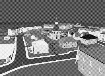
Figure 1: The City
To implement the `City Game' we have chosen VRML 2.0, the Virtual Reality
Modeling Language 1 . The complex scenes of the city are modeled
with CosmoTM Worlds, a powerful editor (and free on Silicon
GraphicsTM workstations) to create VRML worlds. The `City Game'
consists of a realistic city structure and typical buildings and objects
of a city. Animated objects such as a bus or a train enliven this virtual
city. Navigation through the city, along the streets, can be done interactively
with various navigation aids, e.g.
- a 2D-map (bird's view), which shows the actual position of the user
in the city and optionally displays the path covered so far
- road signs and a hard-copy of the city map
- a wind rose for orientation with the four directions of the compass
(Figure 2)
1. ``International Standard (ISO/IEC 14772) file format for describing
interactive 3D multimedia on the Internet." (http://vrml.org/Specifications/)
Interactive navigation can be done by the standard mouse and direction
buttons (forward, backward, left and right) and is implemented through
viewpoint animation by automatically keeping the viewpoint at a fixed height.
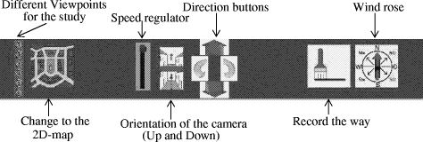
Figure 2: Navigation and Interaction Control
One of our main interests in the 'City Game' is the value it possesses
for teaching children spatial orientation. The use of virtual reality to
improve human abilities in the real world has been proven to be successful
in other areas as well, such as the overcoming of phobias by training subjects
in virtual reality [Strickland et al. 97]. Interest
of the computer science group also expands to general requirements of using
virtual worlds as teaching tools.
3 A First Informal Study
A first informal study was performed to see reactions of children and
adults when using the `City Game'. Another goal was to determine what kind
of features children use for orientation as compared to adults. The study
included ten children (grade four) of an elementary school and ten university
students. Each group consisted of five male and five female subjects. In
this study subjects had to find their way from different initial positions
to different target positions. Each trial should be performed with a different
help or method, e.g. with the city map, with photos along the way to be
found, with the wind rose or by backtracking a way that was shown before.
Additionally after each trial and each session different questions were
asked for reviewing the tasks and the 'City Game', e.g. ``What are you
remembering of the city?``
Before beginning the study each subject was shown a walk through the
city and taught the use of the direction buttons. The subjects were asked
"to think aloud" 2 during performing their tasks.
The comments were recorded by video and in written notes by the evaluator.
4 First Results
An unexpected result was that adults and children hardly used road signs
and the city
2. A common evaluation technique of user interface design.
map for orientation in the virtual city. Their orientation occurred
mainly through buildings with particular characteristics (e.g. function,
size or color). An explanation may be the relatively small number of streets
and the great number of particular buildings. Also the experience with
three-dimensional computer games might influence the behavior of the subjects.
Mostly the navigation help of such games are objects and directions. The
buildings used recurrently for orientation were the museum with a large
dinosaur in front, the church, the city hall, and the school.
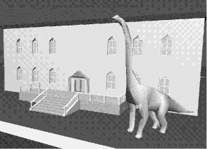
Figure 3: The museum with a large dinosaur
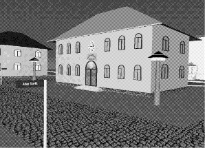
Figure 4: The school
Differences between the children and the adults occurred when they were
asked to remember objects of the virtual city immediately after the session.
The buildings mostly named by the children were (by decreasing frequencies):
the museum with the dinosaur (Figure 3), the school (Figure 4), and the
church. In contrast, the major buildings named by the adults were: grocery,
petrol station (Figure 5) and church, and museum. This
leads to the assumption that children and adults use different objects
for orientation dependent on subjective perception and the experience in
daily life.
One important result was that subjects (both children and adults) often
focused on the navigation tools (mouse and direction buttons) rather than
on their tasks. Nevertheless the reactions of the subjects were very positive
to the `City Game', specifically to the structure of the city, the appearance
of buildings and details. Some of the subjects sug gested populating the
streets with people, who can be asked for directions.
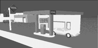
Figure 5: The petrol station
Based on this preliminary study and the extensive development of the
`City Game', we are starting a series of further tests of teaching spatial
orientation in virtual environ ments. We are currently improving the navigation
tools of the `City Game' to develop a more intuitive navigation control
to simulate a natural walk through the city. Formal studies based on more
specific hypotheses will give us a deeper insight into the navigation feature
used by children and adults in virtual and real environments.
References
[Maier 94] Maier, P.H.: ``Räumliches Vorstellungsvermögen
- Komponenten, geschlechtsspezifische Differenzen, Relevanz, Entwicklung
und Realisierung in der Realschule``; Peter Lang GmbH Europäischer
Verlag der Wissenschaften, Frankfurt am Main (1994)
[Strickland et al. 97] Strickland, D., L. Hodges,
M. North, and S. Weghorst: ``Overcoming Phobias by Virtual Exposure``;
Communications of the ACM, 40, 8, (1997), 34-39
Acknowledgment
The authors would like to thank Ralf Stodiek, Olaf Dammrose and Maik
Velser for their support of developing the `City Game' and Tina Brenneisen,
who performed the first informal study. We would also like to thank the
project ``Neue Medien und Lehramtsstudium" within the limits of the
initiative ''Bildungswege in der InformationsGesellschaft" (BIG) whose
financial support has promoted the programming effort.
|